A cut of low pressure system is heading to the central and eastern parts of South Africa on Monday.
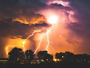
Meteorologists at the Severe Weather and Information Service (Swaicsa), said this system could bring along severe storms.
An incoming cut-off low from the west is expected to bring thunderstorms with heavy rains, hail, and potentially damaging winds to the Northern Cape, Western Cape and Eastern Cape on Wednesday, spreading into the Free State on Thursday.
The South African Weather Service (SAWS) warned against severe thunderstorms with heavy downpours, on Monday, over Gauteng, the Highveld and Escarpment of Mpumalanga, the south-western parts of Limpopo as well as the eastern parts of the North West and Free State.
Extremely high fire danger conditions are expected to continue in the Northern Cape, Free State, the North West and Beaufort West Local Municipality in the Western Cape.
A heat wave persists over Chris Hani, Joe Gqabi and northern parts of Alfred Nzo Districts Municipalities in the Eastern Cape until Wednesday.