Floods in the Garden Route affected farms, led to evacuations of communities, road closures, the postponement of funerals and a widespread power outage on Thursday.
The Western Cape Department of Agriculture urged all farmers in the Region, who were affected by recent storms and flooding, to complete a Storm Damage Assessment Survey for May 2026.
The assessment can be completed on a PC or mobile device.
The Garden Route Multi-Agency Command Centre urged residents to remain cautious since most dams are full, and spilling over, including the Stompdrift Dam, which is at 139%.
Major tourism routes were also affected, including the Meiringspoort Pass, which is expected to remain closed.
The N9 also is closed and is accessible only for emergency services.
Other inaccessible areas in Oudtshoorn, are Middelplaas, Volmoed, Cango Bergoord, De Oude MeulMoeras River, Proefplaas and Meiringspoort.
Others in the Kannaland Municipal area, are Paardebont (close to Van Wyksdorp), Middelpad at Calitzdorp Hot Springs and Gamka-Oos.
In the George Municipal area, inaccessible areas are Mount Hope (past Zebra), De Vlugt and Kammanassie as well as SNK & Fisantehoek as well as Wittedrift in the Bitou.
Humanitarian assistance is expected to come from Gift of the Givers, Al Imdaad and NGO’s with five-day food parcels being prepared for delivery.
Critical water and electricity services were hampered by the floods. This is the case at the Uplands Water Works on the R340, which supplies 80% of Bitou Municipality’s water.
The Bitou Municipality said it has sufficient water in reservoirs for Thursday.
The Municipality’s Roodefontein Pump Station was also been flooded.
In Uniondale, a water pipeline was washed away and water tankers provided by the district municipality.
Continuous rainfall in the area has resulted in a high water table and saturated soil conditions at local cemeteries.
The Oudtshoorn Municipality said these conditions make it unsafe to properly prepare graves in advance and significantly increase the risk of grave wall collapse.
As a result, members of the public are strongly advised to postpone all funerals scheduled for Saturday, 09 May 2026 and Sunday, 10 May 2026 at the Oudtshoorn Cemetery, Dysselsdorp Cemetery and De Rust Cemetery.
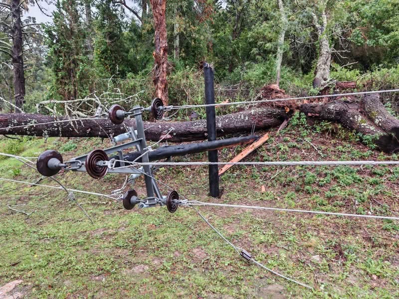
Municipal teams are currently on site in Karatara, where a tree is being removed from the high-voltage line, in Knysna.
This is because the town of Sedgefield is without electricity as well as parts of Plettenberg Bay.
Here is a list of closed roads in the Region:
*Oudtshoorn Area*
DR1707 – Middelplaas (closed)
MR369 – Swartberg Pass (closed)
MR401 – Uniondale Poort (closed)
MR401 – Uniondale town approaches (closed)
MR399 – Avontuur (closed)
*Kannaland Area*
DR1706 – Groenfontein (closed)
MR309 – Seweweekspoort (closed)
*George / Knysna / Bitou Area*
DR1615 – Swart Rivier (closed)
MR346 – Buffelsbaai (closed)
DR1888 – Keurboomstrand (closed)
MR390 – Kruisvallei / Uplands intersection (closed)
DR1613 – Phantom Pass (closed)
DR1602 – Kleinplaas (closed)
DR1633 – Jonkersberg (closed)
DR1604 – Haelkraal (closed)
*Trunk Roads*
TR33/4 – Meiringspoort (closed)
TR44/1 – Avontuur to Eastern Cape boundary (closed)
TR1/2 – Noll to Harold (closed)
TR2/12 – Nature’s Valley to N2 (closed)
TR16/10 – Murraysburg to Graaff-Reinet (closed)
TR58/1 – Molteno Pass (Beaufort West to Loxton) (closed)
TR1/2 – N9 section near Uniondale (closed)
TR33/2 – Oudtshoorn flooded section (closed)
*Roads Open / Partially Open*
*Oudtshoorn Area*
DR1640 – Montagu Pass — one lane open
George / Knysna Area
MR390 – Kruisvallei (km 0–1.44) — open
MR355 – Seven Passes Road — open after tree removal
MR351 – Barrington — open
MR394 – Keurboomstrand — open
*Trunk Roads*
TR34/2 – Prince Albert to Klaarstroom — open
TR31/5 – Huisrivier Pass — stop-and-go system in place
Important details :
Farmers can use the link below or by scanning the QR code on the infographic.
🔗https://survey123.arcgis.com/share/63a2484341a547cf9eb27f5583252add?portalUrl=https%3A%2F%2Fgis.westerncape.gov.za%2Fportal&utm_source=chatgpt.com